By: Alejandro Baño Oyarce / abagno@dgeo.udec.cl | Photographs: Courtesy of the UdeC Department of Geophysics
SWOT, the so-called “Hubble of Earth Sciences”, has been launched into space on a SpaceX Falcon 9 rocket from the “Vandenberg” United States Air Force base, in California. Its nickname was created by a Chilean researcher, who will be part of the satellite mission, namely Rodrigo Abarca del Río.
The satellite, already in orbit, will have the key task of measuring variations in the world’s water cycle and, therefore, checking changes produced mainly by the climate crisis, which is increasing the planet’s temperature and causing regional effects such as drought, floods, and changes in glacier, lake, and river levels.
“For Chile, we will be able to study our rivers and lakes, variations of ice fields, and the effects of drought, because in our country there are almost no instruments to measure on the ground. This global innovation will produce a great leap for national and planetary science,” said the doctor in Geophysics at UdeC and an expert in Spatial Geodesy and Climatological Hydrology.
The researcher is also responsible for the scientific project in South America, together with a team of Brazilian researchers. He explained that after the launch, calibration and validation of satellite data must be done in different parts of the world. That is to say, the information provided by the satellite must be corroborated on the ground, a task that Dr. Abarca will also carry out in Chile, accompanied by the main researcher of the project in the hydrological area, the French scientist Dr. Jean Francois Cretaux, an expert in Satellite Altimetry and Spatial Geodesy.
Both are traveling to Fagnano Lake, in Tierra del Fuego, to carry out the observation and measurement work that will be compared with the data captured by the SWOT satellite for the same body of water. “We will do the same in the Bío Bío River and in lakes in southern Chile,” said Dr. Abarca.
The information collected by the satellite will be available to anyone after six months of exclusivity for those who organized and financed the space mission. “This will allow us to greatly improve research on oceanographic and hydrological processes in Chile and the planet”, the UdeC Geophysics professor said enthusiastically.
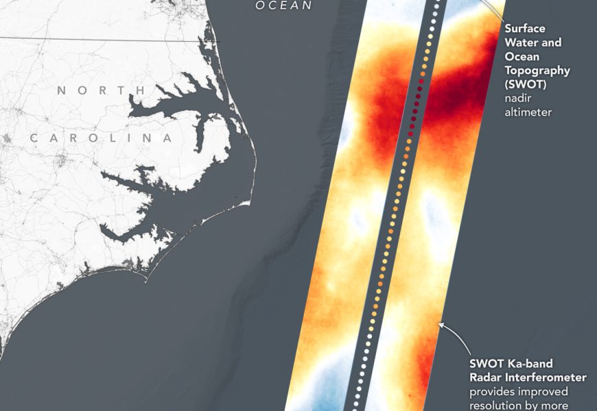
The SWOT mission, with its radar altimetry and interferometry technology, will be able to cover all water bodies larger than 100 meters in diameter with repeated high-resolution elevation measurements, providing fine-detail observations of the ocean surface topography and measuring how lakes and rivers change over time.
The data will provide the critical information needed to assess water resources on Earth, track regional sea level changes, monitor coastal processes, and observe small-scale ocean currents and eddies.
Last modified: 29 de agosto de 2025