
With the participatory techniques of social cartography, World Cafe, workshops and keynote talks, Universidad de Concepción researchers were able to identify key places and make proposals in order to implement, in a sustainable manner, preferential areas for recreational fishing in Los Ríos Region, promoting this type of special interest tourism and respecting natural cycles.
By Paulina Hernández
/ phernandezj@udec.cl
/ Photografies: Courtesy of FCNO
With the idea of creating and transmitting a territorial planning proposal, based on a special interest tourism strategy and specifically a recreational fishing tourism in Los Ríos Region, a project was carried out between November 2018 and January 2020, which included the field work of an interdisciplinary team of specialists, integrated in the social area by the associate researcher of INVASAL and academic of the Faculty of Social Sciences UdeC, MA. Beatriz Cid, and the sociologists: MA. Jose Barriga and MA. Andrea Núñez, and the administrator of Tourism Companies, Marisiel Pérez; in addition to the biologists: Pablo Rivara, Selim S. Musleh, Carla Muñoz-Mendoza, Poliana Strange and Mauricio Cañas-Merino.
COLLABORATIVE DIAGNOSIS
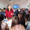
The first part of the project, the diagnosis, was based on two specific methodologies: one based on interviews with key actors and the other on the construction of social cartographies. The latter ones were developed in workshops where, from a cartographic projection of the rivers, the recreational fishing users identified key places for fishing, spawning, difficult access or poaching.
With the use of cartographies, a projection of relevant problems and topics was carried out in a participatory dialogue with the exercise of social cartography. This one, unlike the classic cartographic map, does not show a precise georeferencing; the important thing is to talk about what people are able to identify on the map. “ It helps you to place both history and the situational map of the territory in the right order” It allows to have a tool to generate an administration of the preferred recreational fishing areas, which is what the Regional Government was looking for by encouraging this project”, explained the sociologist José Barriga.
During the second stage of the project, the first results, which involved precisely these social maps, were presented. Georeferencing was used for the Fuy and Enco rivers, in the case of Panguipulli; the Caunahue, Calcurrupe and Hueinahue rivers, in the case of Futrono and Lago Ranco; and the San Pedro river in the case of Los Lagos district.
For the MA. Daniel Gomez-Uchida, director of INVASAL and academic of the Faculty of Natural and Oceanographic Sciences of the Universidad de Concepción (UdeC), this project contributes to fill a gap, making an appropriate territorial diagnosis and proposing a successful management model which integrates different actors involved in recreational fishing. “We feel that we are at a turning point and hopefully the first preferred recreational fishing areas will be created in Los Ríos Region in order to consolidate this as an instrument that allows this special interest tourism activity, moving forward to an economic activity that provides resources and empower the communities involved in a sustainable (manner) way over time”.
In consideration of all the interaction and experience present in the territories of Los Ríos Region, the implementation of a preferred recreational fishing area is projected, the first one in Chile, and the work contributed by INVASAL experts was key in order to construct that reality.For more information please contact: dgomezu@udec.cl
Last modified: 29 de agosto de 2025